Primer on the issues written by Civil Engineer Fred Beukema in 2017
LAKE HIAWATHA GOLF COURSE: A PRIMER, WITH LINKS!
Written by Fred Beukema, a registered professional civil engineer in the state of Minnesota
The marquee issue in the Minneapolis Park & Recreation Board (MPRB) election this year is the fate of the public Hiawatha Golf Course in south Minneapolis. Based on what I’d read about the course and the Park Board’s decision-making process, this civil engineer has been fairly annoyed by unfounded assertions of how easy it would be to keep the course open indefinitely in its current, 18-hole configuration. So I did some digging, and would like to explain why the easy, happy solutions being touted by Minneapolis golf boosters are unrealistic.
I’ll start by acknowledging my sources:
The Park Board’s own FAQs on the golf course, found here and here, and their July 2017 executive summary presentation.
Barr Engineering was retained by the Park Board to perform a water management study of the course, and their February 2017 report was perhaps the single most important source for me. It’s a technical document, but to the extent that I reference it, I’ll try to help annotate it.
I recommend the blog of St.-Paul-based sci-fi & fantasy author, and evergreen electoral citizen journalist, Naomi Kritzer, who has also blogged on this subject and whose efforts to engage with local political ephemera are a major inspiration for this effort.
Tesha M. Christensen at the Longfellow Nokomis Messenger has a lot of well-reported stories about the Park Board’s decision making process and the public discussions.
Finally, I turned to a college friend who is also a Minnesota-registered Professional Engineer (PE), though her background is actually in water resources science, and she is an environmental scientist by practice. Her explanations and the additional detail she was able to provide were tremendously helpful.
THE PROBLEM WITH LAKE HIAWATHA AND THE GOLF COURSE
June 2014 was the wettest month in modern Minnesota records, and south Minneapolis saw widespread flooding. My wife and son and I were living at the time on the block just north of the Hiawatha Golf Course, and saw the water covering the fairways on our side of the course for much of the summer. Here’s some WCCO footage of what things looked like in late July of that year, when the course was reopened as a nine-hole course. The damage to the course was significant, and the Park Board started a process to determine how to mitigate future flooding.
Minnehaha Creek flows through Lake Hiawatha, which means that all of the creek’s upstream watershed, including every other lake in south Minneapolis, as well as Lake Minnetonka, drains through the lake. Several storm sewer outlets pour into the golf course. The groundwater below the course is shallow, contributing further to the inflow. Meanwhile, much of the golf course lies below the surface level of the lake, so if the water level rises, it overtops the earthen berm (dike) that separates the lake and the course, and those low-lying portions of the course flood. This is partially by design: good flood management means you want to have flood plain areas like a golf course, or the various fields adjacent to Minnehaha Creek, to flood in a major rain event, instead of the neighboring streets and private properties.
The problem here is that keeping the water out of the golf course and in the lake requires the Park Board to actively, constantly pump it from one side of the berm to the other, even as some of that water seeps back through the berm to the course. This pumping doesn’t just keep the course dry: there are between 9 & 18 homes adjacent to the northwest corner of the course whose basements will flood if the pumping stops.
The MPRB has a license from the Minnesota Department of Natural Resources (DNR), allowing them to pump up to 36.5 million gallons per year (MGPY). The process of developing new flood mitigation plans for the future revealed that the current level of pumping is upwards of 250 MGPY, well beyond the Park Board’s license.
The Park Board announced in 2017 that they would close the course in its current form. Following public outcry, they have announced plans to keep it open as is for five years while they either figure out if their decision was the right one, or figure out how to sufficiently sell it to the public (take your pick).
SO WHY NOT KEEP PUMPING THAT MUCH?
Repairing the course following the 2014 flood damage was a huge expense, and that expense will continue to recur anytime a significantly wet summer pushes the lake above its berm. The climate forecast for Minnesota calls for generally wetter summers than what used to be normal, which means that floods of the course will become more frequent. A major danger here is the berm itself: water flowing through and over the berm weakens its structure, and if it fails, that’s the ballgame for the current water management scheme.
Also, the constant draining of groundwater from under the golf course causes the soil to compact, further contributing to long-term settlement of the flood-prone area. This could be a major risk in the future for the adjacent flood-prone houses, resulting in voids and therefore potential sinkholes beneath their basement floor slabs. I don’t mention this flippantly.
Then there is the regulatory problem. If the MPRB flouts the DNR’s oversight of this pumping, this weakens the ability of the agency to protect lakes, streams, and rivers in the state. Furthermore, the authority to make changes here lies with several agencies above the Park Board and the city. From the Park Board’s FAQ:
“Any alterations such as excavation, filling, or changing water levels of the lake, the creek, or their floodplains would require permits and approvals from some or all of the following regulatory agencies: the Minnesota Department of Natural Resources (DNR), Minnehaha Creek Watershed District, the Federal Emergency Management Agency (FEMA), and the Army Corps of Engineers. The Minneapolis Park and Recreation Board and City of Minneapolis do not have jurisdiction over these matters. Obtaining the necessary permits and approvals to alter lakes, streams, wetlands, and floodplains is difficult in Minnesota. Any proposed alterations to Lake Hiawatha and/or Minnehaha Creek may be denied by one or several of the agencies with jurisdiction.”
It’s my understanding from conversations with people more connected to this that FEMA has pledged the MPRB a significant grant toward the work on the golf course. (Park Board District 5 Commissioner Steffanie Musich pointed me to the project’s manager for details and clarification, but I haven’t heard back from him yet. Will update if I do.) If a FEMA grant is used to maintain the water management status quo, which in turn leads to future significant flood damage, that would be pretty poor stewardship of the Park Board’s fiscal resources, and the Federal Government’s assistance.
IS THE PUMPING AN ENVIRONMENTAL PROBLEM?
This was my first question for my environmental scientist friend. She explained to me that the water quality of the lake is directly impacted by fertilizer and pesticides from the golf course, trash in the incoming storm water, and (most significantly) whatever comes downstream from the rest of the creek watershed. And of course, the pumping interacts with all those water sources. But the pumping itself is not the problem.
The MPRB installed new water retention ponds in the golf course in 2012 to provide an additional filter between some of the storm water sources and the lake (you can see the storm sewer, including the pond system, in Figure 13 of the Barr report - we used to stop on the way home that year to look at the workers and equipment building Pond A, and the waterfowl that would swim there). The ongoing project to mitigate incoming water pollution was halted when the magnitude of pumping was discovered post-flood.
CAN WE LOWER THE WATER LEVEL BY DREDGING THE LAKE?
No. Kritzer commented in her write up that the idea of the lake as a bowl that you can make bigger isn’t quite true, but my environmental scientist friend explains that the metaphor is actually pretty good. Imagine there’s a mixing bowl (Lake Hiawatha) in your sink. Water’s flowing in from the faucet (Minnehaha Creek upstream), and it pours out of a spout at the edge of the bowl (Minnehaha downstream). If you make the bowl deeper (by replacing it with a bigger mixing bowl), the bowl will take longer to fill up, but it will still fill. The way to make the water in the bowl stay lower is to lower the water level of the outflow (tip the bowl, or cut a deeper notch in the side, or something). Which brings us to the downstream creek.
CAN WE LOWER THE WATER LEVEL BY LOWERING THE DOWNSTREAM CREEK?
If the water level of the creek downstream of the lake were lowered, it would lower the lake level. There are two elements to the downstream creek that can affect its surface level: the actual profile of the creek bed, and weirs.
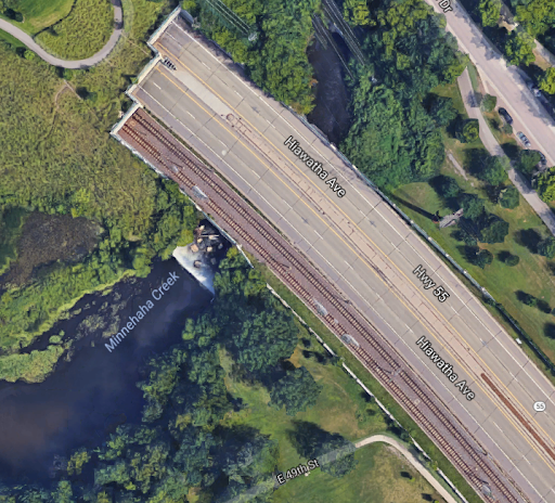
Weirs are vertical plates, walls, or similar barriers stuck in flowing water to control the level, rate of flow, and sometimes to prevent larger material floating onward. In this segment of the creek, there are several. The three most notable are a concrete weir where the creek exits the lake (seen here in a photo provided to the Southside Pride neighborhood newspaper by Park Board candidate Charlie Casserly — I’ll return to this piece in a moment), a rock dam of unknown origin at the 30th Ave pedestrian bridge, and a weir just before the tunnel that takes the creek under Hiawatha Avenue and the Blue Line Light Rail, shown below (screenshot from Google Maps) - the white water is the creek spilling over this weir.
We’re going to get into some detail here, because I think this is where many of the assertions by golf course advocates just aren’t true, and where I’ve found better information in the primary sources.
Here’s a figure excerpted from the Barr report. It shows the elevation profiles of the creek bed and the creek surface, both surveyed in early 2017. They mark certain notable features, and I’ve added a few remarks myself. This portion of the creek includes two of the three weirs described above..
The concrete weir across the creek outflow at the lake is submerged and, according to candidate Casserly in that Southside Pride piece, has been for years. This means that if you remove it, it won’t really affect the water level. The rock weir at the 30th Ave pedestrian bridge is a high point, but there are high points in the creek bed of similar elevation close by in both directions.
The discussion of the creek surveys on page 25 of the Barr report remarks that there are utilities crossing under the creek in this area. Lowering subgrade utilities is generally quite expensive. But the MPRB FAQs (one and two) identify one of these utilities in particular: a 10 foot x 11 foot wastewater interceptor (read: “poop sewer main”) operated by Metropolitan Council Environmental Services (MCES) crosses under the creek bed. MCES collects wastewater from almost all of the Twin Cities metro area, as far west as Corcoran and as far north as Forest Lake, transfers it*, and treats it – on average 172 million gallons per day – at the Metro Plant just downriver of downtown St. Paul. This particular interceptor is the waste sewer artery in that system for much of south Minneapolis, stretching back to the southwest corner of the city. My friend has access to the MCES Geographical Information System (GIS), which shows us where this crosses the creek. The high point is between 28th & 29th Ave (I’ve marked this in the diagram), but it crosses under the creek a total of five times between Lake Hiawatha and Hiawatha Ave.
From the MPRB pumping FAQ:
“[T]he most the creek could be excavated and still maintain cover over this pipe is approximately 1.0 foot. The pipe would still need some level of reinforcement/ stabilization over the pipe. There are also several bridges/crossing downstream of Lake Hiawatha that would likely need to be modified or reconstructed to achieve the lower channel elevation. Additionally, the creek channel would need to be redesigned, restored to achieve a stable channel and banks, and from an ecological standpoint will take significant time to reestablishing the existing biological communities. …
[T]he impacts of lowering Minnehaha Creek by 1-foot, resulting in a 1-foot drop in average water level of Lake Hiawatha, are not enough to resolve the water problems at the golf course, because it reduces the average total annual groundwater pumping required by approximately 22 million gallons per year (MGY). This means, approximately 220 MGY of groundwater pumping is still required to protect homes and maintain [the] golf course.”
As for the weir by Hiawatha Ave, which IS controlling the local level of the creek, it has good reason to be there, and removing it again won’t make a big difference upstream at the lake. It’s outside the bounds of the Barr Report, but you can see it here in the FEMA flood profile for the creek, excerpted from the agency’s 2016 revision of a flood insurance study. It’s important to note that the survey data here is older, and apparently predates the rock weir at 30th Ave. It is also of a coarser resolution than the Barr Report is for the segment it covers (I’ve marked this in the diagram). You can see in the diagram that the creek bed is higher than the Hiawatha Ave weir in multiple locations between it and the lake, which means the effect of this weir on the lake itself is minimal. You also want a way to control the flow of water entering the Hiawatha Ave tunnel: if the water level of the creek were to reach the underside of the tunnel, it could cause significant damage to a major transportation corridor with no way of accessing it until the waters subside.
(A note here about Southside Pride. Ed Felien, the editor and publisher of the paper, has written repeatedly about the golf course, and made a lot of claims about how the whole system works, many of which show deep misunderstanding of it. A lot of the preceding paragraphs are intended to address his claims about the weirs and the idea of dredging the creek, but I want to note a couple of other points he has made:
He blames Hubert H Humphrey for installing weirs in the creek to increase the flow of Minnehaha Falls and impress LBJ when they visited the falls on the 1964 campaign trail. Weirs would tend to depress the waterfall’s flow, not increase it. The version of this story I’d always heard, and which is described in a marker at the falls, says that during that low-creek summer, they opened fire hydrants to pump up the Falls.
He quotes a park staffer explaining that “there are piles of sand at some of the storm sewer outlets that empty into Minnehaha Creek,” and concludes that therefore sediment from the storm sewer has raised the lake bed. Again, scooping out the lake bottom won’t help.
As previously explained, the weir at the creek outlet is completely underwater, and therefore holding back zero feet, not “at least 2 feet.”
He seems to write about the subject in every issue, and his claims about the causes and solutions to the flooding are all over the place. Unfortunately, he’s got a very large megaphone in his south Minneapolis community for his false confidence.)
CAN WE KEEP THE GOLF COURSE DRY BY RAISING IT?
Another solution floated by golf course boosters has been to dredge from the lake and/or creek and use that fill to raise the low-lying areas of the golf course. This could indeed keep the course dry, but it wouldn’t fix the problem of the lake overflowing in a flood, and now the water would seek the next lowest areas to go, which would be neighboring streets and private property.
SO: WHAT TO DO?
Following a series of public meetings and engineering investigations, the Park Board ultimately outlined two main options (see the July 2017 Executive Summary for more detail). Option A would be the status quo, requiring continued pumping of volumes an order of magnitude larger than the DNR permit (and therefore, DNR permission), and carrying the long-term risks described above. Option B would be to turn off the pumps for the course, abandon the idea of an 18-hole course at this site, take steps to mitigate basement flooding, and redevelop the site. The Park Board has stated a desire to return the creek inflow to its natural position closer to the SW corner of the site and restore more of the wetlands, which would help clean more of the water entering the lake from the watershed. Most notably, this option could include a 9-hole golf course on the remaining dry land, or a number of other uses that the Park Board and residents have proposed.
The “Save The Hiawatha Golf Course” campaign is focused entirely around the current, 18-hole course. (I think I’d be remiss if I didn’t link to their materials as well: Save Hiawatha 18 is a clearinghouse of pro-18-hole information!) For all the reasons above, I don’t find it persuasive that this would be a prudent use of the Park Board’s resources, if the regulatory bodies would even allow it, and we would likely find ourselves in the same or worse position some years down the road.
There is a strong argument for keeping a 9-hole course here. Hiawatha is the only public golf course in South Minneapolis (the MPRB has a nine-hole course relatively nearby at Ft. Snelling and four other 18-hole courses, one in North Minneapolis, two in Northeast, and one in Hopkins). Golf is a popular sport and to some extent a business-related skill, and a public course open to people who would not be able to afford playing at a private club is a good resource to have among the many assets in our park system. (It is worth noting the historical significance of this particular course being one of the first in the area to admit African Americans.) There are a lot of other interesting ideas for the site, some of which may be able to exist alongside a 9-hole, some of which probably wouldn’t. But I for one certainly support saving room in a redeveloped site for nine holes.
(Long term, it would not surprise me if the Park Board also seeks to buy some of the most vulnerable houses adjacent to the course, in order to further mitigate flooding and reduce active water management needs. It wouldn’t be the worst idea.)
THE ELECTION
There are races for Park Board Commissioner going on in all six of the Board’s districts, and for three at-large seats. The issue of the golf course has drawn additional, single-issue, pro-18-hole candidates into the races. I urge everyone to research the candidates, but I will note that many of the single-issue candidates seem to be trading in bad science and alarmism, and some don’t seem to have much in the way of a developed platform beyond the course (nor an apparent understanding of the job’s responsibilities). Some of the more thoughtful candidates are voicing pro-18-hole positions while acknowledging the ongoing process and jurisdictional limitations; this strikes me as a politically smart position to take in this moment, but I think the 18-Holes-Or-Bust crowd is louder (and certainly has more lawn signs and local newspaper ads). Kritzer has been researching and writing up each race, which is a wonderful place to start, and shows how you can start your research online yourself. Sometimes, though, the information online is incomplete, and you can learn more by emailing a candidate questions, or attending any campaign events in this last week before Election Day on November 7th.
TL; DR
If nothing else, I hope you take away a few ideas:
The issues facing the golf course are real. Keeping an 18-hole course is risky, and mitigating the risks will be exceedingly expensive.
The Park Board’s decisions were made after significant study and consideration.
A 9-hole golf course could still be a part of the post-renovation park, and is worth fighting for.
Those who claim that keeping the 18-hole course is a matter of preference, and that doing so is as simple as maintaining the status quo, are largely dismissing evidence and professional judgment.
Please consider that last point when voting for your Park district commissioner and the at-large commissioners, especially if a particular candidate doesn’t seem to have much to say beyond the golf course.
Fred Beukema is a registered professional civil engineer in the State of Minnesota, with thirteen years of experience in structural engineering. Other than four years of college in Iowa, he is a lifelong resident of south Minneapolis. He lives in the Diamond Lake neighborhood with his wife, two kids, and a couple of cats. Inquiries about this piece may be sent to fred.beukema@gmail.com.
The views expressed above are solely those of the author, and do not represent the views of his employer nor (except as quoted) of the Minneapolis Park & Recreation Board, the Federal Emergency Management Agency, or Metropolitan Council Environmental Services. The author received no compensation for the writing of this piece, and could have better spent the time sleeping, or reading for pleasure.
* I previously mentioned that the MCES wastewater system transferred entirely by gravity. This is incorrect, as the system does include a number of lift stations.